


University of Exeter Press
Historical Atlas of South-West England
Couldn't load pickup availability
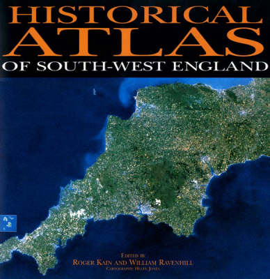
This is the first historical atlas of a major region of the United Kingdom. Its aim is to create and communicate the history of the south-western peninsula of England-Cornwall, Devon and the Isles of Scilly - from the beginnings of man's occupation to the present day. The cartographic message projected by around 400 maps is extended by a substantial text of about 250,000 words as well as diagrams, contemporary prints and photographs.
This is one of the most substantial collaborative cartographic ventures undertaken in the United Kingdom. There are more than fifty contributors, about half of whom are drawn from within the University of Exeter, the remainder being researchers at other universities who specialize on topics relating to South-West England. The majority are geographers, archaeologists and historians, but there are also important contributions from political scientists, sociologists, educationalists and the region's museums, library and archive services.
The pre-medieval content is organized chronologically but thereafter the reconstruction of human occupation is structured thematically
“Not to be missed by historians, geographers, and archaeologists who might wish to acquire an almost perfect example of the genre . . . Text, maps, and illustrations are at once authoritative, clear and unambiguous . . . A key text for future studies of the south-west.” (Journal of Historical Geography 27, 2001) “Where this atlas wins hands down over its rivals is its massive inclusiveness and the depths of the articles that accompany the maps. Coverage runs from the geology of the South West and its palaeolithic settlement patterns right up to the contemporary hot potato of second home ownership. The general editor, Roger Kain, points out that ‘Each author was given the opportunity to frame his or her own contribution within broad parameters set by the editors.’ This lightness of touch has worked in that it is quite possible to sit down and view the atlas as a ‘good read’ in its own right . . . The 65 chapters cover everything a local historian or geographer could reasonably want to know and many are a masterpiece of compression and data presentation.” (The Local Historian, November 2000) “. . . massively comprehensive and detailed, with a proliferation of excellent colour and black and white reproductions, diagrams and photographs, as well as some 400 specially drawn maps . . . Its worth as a work of reference for the specialist can be judged by, for example, the linguistic scientist being able to turn to a chapter, complete with relevant map, on the retreat of the Cornish language, or the social historian to a remarkably well illustrated chapter on printing, the book trade and newspapers. This is not to say that it is of lesser interest to more generalist readers, such as map collectors or, indeed, anyone with more than a passing interest in the peninsula.” (Journal of the International Map Collectors Society, Autumn 2000) “A very fine production . . . provides good value on the historical and geographical background to that fascinating south-western peninsula of England.” (The Geographical Journal March 2001, Vol. 167) “This marvellous book.” (Mapline, Vol. 91 2000) “The enduring hold of local history on the imagination is also manifest in Roger Kain and William Ravenhill’s sumptuous Historical Atlas of South-West England, the product of twelve years’ work and one of the most substantial collaborative cartographic ventures undertaken in the United Kingdom.” (Journal of Historical Geography) “Thanks to generous contributions from the University of Exeter Development Fund and a series of charitable organisations, this Atlas sells for £55, which is extraordinarily cheap at the price and not to be missed by historians, geographers, and archaeologists who might wish to acquire an almost perfect example of the genre.” (Journal of Historical Geography) “… the contributors to the Historical Atlas of South-West England have given us a volume which is as beautiful as it is scholarly; a handsome work to be enjoyed by student and ‘general’ reader alike.” (Journal of Historical Geography)
Contents: Environmental setting, Christopher Caseldine; traditional building materials and their influence on vernacular styles, Veronica Chesher. The deep past - before the Norman Conquest: palaeolithic - the earliest human occupation, Allan Straw; late Upper Palaeolithic and Mesolithic hunting-gathering communities, Alison Roberts; Neolithic settlement, land use and resources, Frances Griffith and Henrietta Quinnell; barrow and ceremonial sites in the Neolithic and earlier Bronze Age, Frances Griffith and Henrietta Quinnell; settlement c.2500 BC to c.AD 600, Frances Griffith and Henrietta Quinnell; the Bronze Age metalwork of Devon and Cornwall, Susan M. Pearce; Iron Age to Roman buildings, structures, and coin and other findspots, Frances Griffith and Henrietta Quinnell; the Roman Army in the South West, Valerie Maxfield; classical sources for the ancient South West, Malcolm Todd; early Christian Dumnonia, A.C. Thomas; place names in Devon and Cornwall, O.J. Padel; Saxon conquest and settlement Della Hooke. Themes in the history of post-medieval South-West England - population: population distribution from the Domesday Book of 1806 William Ravenhill; population distribution and growth in early modern England Jonathan Barry population change in south-west England, 1811-1911, Andrew Alexander and Gareth Shaw; population changes in the 20th century, Andrew Gilg. Themes in the history of post-medieval South-West England - political and military history: castles, fortified houses and fortified towns, 1300-1500, Robert Higham; representation and rebellion in the later middle ages, Nicholas Orme; civil wars of the 17th century, Peter Gaunt; coastal defences and garrisons, 1480-1914, Michael Duffy; defence and disruption - World Wars I and II, Mark Blacksell; antecedents of the modern administrative map - local areas and local authorities, 1801-1998, Jeffrey Stanyer; Parliamentary boundaries and political affiliations, 1918-1997, Michael Rush. Themes in the history of post-medieval South-West England - religion and religious institutions: ecclesiastical institutions in 1086 and monastic houses c.1300, Christopher Holdsworth; the Church in Devon and Cornwall from c.1300 to the Reformation, Nicholas Orme; religion and the spread of nonconformity before 1800, Jonathan Barry; religious worship in 1851, Bruce Coleman; religion and ecclesiastical practices in the 20th century, Grace Davie and Derek Hearl. Themes in the history of post-medieval South-West England - education/dissemination of knowledge/language: printing, the book trade, and newspapers, c.1500-1860, Ian Maxted; education in Cornwall in the 19th and 20th centuries, L. Burge and F.L. Harris; education in Devon in the 19th and 20th centuries, Roger Sellman; the retreat of the Cornish language, Philip Payton. (Part contents)
- 588 Pages